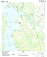
1991 Map of Picolata
USGS Topo · Published 1991About this map
The eastern shore of the ST Johns River in St. Johns County defines this coastal landscape, where the historic settlement of Picolata sits near the site of Spanish-era fortifications. Moving inland, the topography is marked by a series of small riverside communities and landings, including Magnolia Landing and Bass Haven. The map reveals a transition from the wide river waters to the marshy tributaries of Sixmile Creek and Wards Creek, which snake through the eastern interior. An Old Railroad Grade cuts across the center of the sheet, providing evidence of former timber or transportation corridors that once linked these river settlements to the state's interior. Local genealogy is well-represented through numerous rural houses of worship, such as Mt Pleasant Ch and St Joseph Missionary Ch, alongside the Bakersville Cem, anchoring the social history of these unincorporated coastal reaches.
Find a feature on this map
38 named features on this map. Tap any name to fly to it.
Don’t see what you’re looking for? This feature index may not catch every label — zoom into the map to look around manually.
Map Details
Editions of this 1991 Picolata Map
This is the sole edition of this map. No revisions or reprints were ever made.
Other maps of this area

1917 · Orange Park
USGS Topo · 1:62,500

1918 · Orange Park
USGS Topo · 1:62,500

1918 · Palm Valley
USGS Topo · 1:62,500

1937 · Bakersville
USGS Topo · 1:24,000

1937 · Elkton
USGS Topo · 1:24,000

1943 · St. Augustine
USGS Topo · 1:62,500

1947 · Bostwick
USGS Topo · 1:50,000

1948 · Jacksonville
USGS Topo · 1:250,000

1949 · Bostwick
USGS Topo · 1:24,000

1949 · Green Cove Springs
USGS Topo · 1:24,000