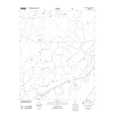
2011 Map of Piedmont NW
USGS Topo · Published 2011About this map
Tallasseehatchee Creek and Nances Creek drain this section of Calhoun County, where agricultural lands meet the foothills of Saddler Mountain and Penny Mountain. The landscape is defined by rural settlement patterns at locations like Knightens Crossroads and Estes Crossroads, where local road networks converge. Genealogists will find several burial grounds including Lebanon Cemetery, Pisgah Cemetery, and Littlejohn Cemetery, alongside local landmarks like the Piedmont Springs Church Camp. Modern agricultural operations such as Millers Poultry Farm Number 1 are documented near the eastern border. This 2011 survey also details several small reservoirs including Lake Watson and Lake Hollis, reflecting a reliance on local water management via Rankins Dam and Boozer Dam. The southern portion of the map identifies the small community of Maxwellborn along the railroad corridor, capturing the persistence of historic crossroad identities in this part of Alabama.
Find a feature on this map
93 named features on this map. Tap any name to fly to it.
Don’t see what you’re looking for? This feature index may not catch every label — zoom into the map to look around manually.
Map Details
Editions of this 2011 Piedmont NW Map
This is the sole edition of this map. No revisions or reprints were ever made.
Other maps of this area

1893 · Fort Payne
USGS Topo · 1:125,000

1898 · Fort Payne
USGS Topo · 1:125,000

1900 · Fort Payne
USGS Topo · 1:125,000

1900 · Anniston
USGS Topo · 1:125,000

1947 · Colvin Gap
USGS Topo · 1:24,000

1947 · Jacksonville
USGS Topo · 1:24,000

1947 · Jacksonville
USGS Topo · 1:62,500

1953 · Atlanta
USGS Topo · 1:250,000

1955 · Rome
USGS Topo · 1:250,000
1956 · Jacksonville
USGS Topo · 1:24,000