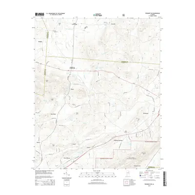
2014 Map of Piedmont NW
USGS Topo · Published 2014About this map
The rugged intersection of several Northeast Alabama counties defines this landscape, where Colvin Mtn and Choccolocco Mtn rise above a network of springs and creeks. Historically significant as a crossroads, the area features numerous small communities like Estes Crossroads, Knightens Crossroads, and Maxwellborn. In the southern portion of the sheet, the Talladega National Forest marks a transition into more heavily wooded terrain near the settlement of Nances Creek. Water resources are abundant, evidenced by numerous named sources such as Hendon Spring, Robertson Spring, and Hopewell Springs, which fed the agricultural and domestic needs of the region. Family and local history are anchored by several established burial grounds, including Lebanon Cem and Pisgah Cem, situated near Gnatville in the northeast. This topography shows the enduring rural layout of Calhoun County as it appeared in the early 21st century.
Find a feature on this map
99 named features on this map. Tap any name to fly to it.
Don’t see what you’re looking for? This feature index may not catch every label — zoom into the map to look around manually.
Map Details
Editions of this 2014 Piedmont NW Map
This is the sole edition of this map. No revisions or reprints were ever made.
Other maps of this area

1893 · Fort Payne
USGS Topo · 1:125,000

1898 · Fort Payne
USGS Topo · 1:125,000

1900 · Fort Payne
USGS Topo · 1:125,000

1900 · Anniston
USGS Topo · 1:125,000

1947 · Colvin Gap
USGS Topo · 1:24,000

1947 · Jacksonville
USGS Topo · 1:24,000

1947 · Jacksonville
USGS Topo · 1:62,500

1953 · Atlanta
USGS Topo · 1:250,000

1955 · Rome
USGS Topo · 1:250,000
1956 · Jacksonville
USGS Topo · 1:24,000