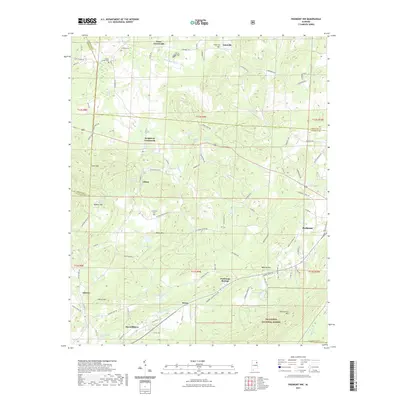
2021 Map of Piedmont NW
USGS Topo · Published 2021About this map
Piedmont occupies the eastern edge of this landscape, where the foothills of the southern Appalachians begin to rise. The terrain is defined by a series of prominent ridges, including Colvin Mtn and Choccolocco Mtn, which frame narrow valleys fed by Tallasseehatchee Cr and Ballplay Cr. Much of the southern portion of the map is protected within the Talladega National Forest, illustrating the region's characteristic mix of timberland and rural settlement. Scattered through the valleys are long-established communities and junctions such as Maxwellborn, Gnatville, and Knightens Crossroads. Several local burial grounds, including Pisgah Cem and Taylors Chapel Cem, are situated near these crossroads, providing vital points of reference for genealogists tracing family roots in northern Calhoun and Cherokee counties.
Find a feature on this map
91 named features on this map. Tap any name to fly to it.
Don’t see what you’re looking for? This feature index may not catch every label — zoom into the map to look around manually.
Map Details
Editions of this 2021 Piedmont NW Map
This is the sole edition of this map. No revisions or reprints were ever made.
Other maps of this area

1893 · Fort Payne
USGS Topo · 1:125,000

1898 · Fort Payne
USGS Topo · 1:125,000

1900 · Fort Payne
USGS Topo · 1:125,000

1900 · Anniston
USGS Topo · 1:125,000

1947 · Colvin Gap
USGS Topo · 1:24,000

1947 · Jacksonville
USGS Topo · 1:24,000

1947 · Jacksonville
USGS Topo · 1:62,500

1953 · Atlanta
USGS Topo · 1:250,000

1955 · Rome
USGS Topo · 1:250,000
1956 · Jacksonville
USGS Topo · 1:24,000