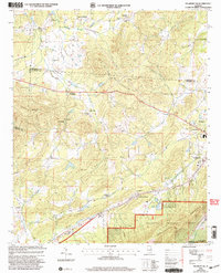
2001 Map of Piedmont NW
USGS Topo · Published 2004About this map
The intersection of Knightens Crossroads and the ridge of Colvin Mountain anchor this portrait of northeast Alabama at the start of the twenty-first century. This landscape is defined by its rural crossroads and scattered spiritual hubs, from Roberts Chapel near Maxwellborn to Pisgah Ch in the north. The area shows a distinct transition from the forested heights of the Talladega National Forest and the Dugger Mountain Wilderness down to the residential fringes of Piedmont. Local recreation and community landmarks appear throughout, including the Drive-in Theater and several small water bodies such as Boozer Lake and Lake Haven. The geography is traced by the winding path of Ballplay Creek, while the presence of the Webb Sch site and various small family-named settlements like Asberry and Allsop offer specific points of interest for genealogists tracing local lineage.
Find a feature on this map
37 named features on this map. Tap any name to fly to it.
Don’t see what you’re looking for? This feature index may not catch every label — zoom into the map to look around manually.
Map Details
Editions of this 2001 Piedmont NW Map
This is the sole edition of this map. No revisions or reprints were ever made.
Other maps of this area

1893 · Fort Payne
USGS Topo · 1:125,000

1898 · Fort Payne
USGS Topo · 1:125,000

1900 · Fort Payne
USGS Topo · 1:125,000

1900 · Anniston
USGS Topo · 1:125,000

1947 · Colvin Gap
USGS Topo · 1:24,000

1947 · Jacksonville
USGS Topo · 1:24,000

1947 · Jacksonville
USGS Topo · 1:62,500

1953 · Atlanta
USGS Topo · 1:250,000

1955 · Rome
USGS Topo · 1:250,000
1956 · Jacksonville
USGS Topo · 1:24,000