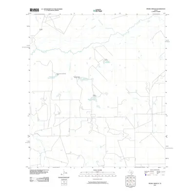
2010 Map of Piedra Creek SE
USGS Topo · Published 2010About this map
The Nueces River winds through this South Texas landscape, carving a serpentine path across the northern reaches of the quadrangle. This 2010 topographic record highlights a region defined by extensive hydrological management and energy extraction, centered around the Rodriguez Oil Field in the northwest. A series of constructed reservoirs and dams, including Charamusca Lake Number 4 and Charamusca Lake Number 7, manage the drainage of seasonal waterways like Charamusca Creek. The terrain is marked by the branching networks of Piedra Creek and Juanita Creek, while a sparse grid of rural routes such as Withers Rd and Co Rd 402 provide the primary access to these remote ranching and oil-producing lands.
Find a feature on this map
17 named features on this map. Tap any name to fly to it.
Don’t see what you’re looking for? This feature index may not catch every label — zoom into the map to look around manually.
Map Details
Editions of this 2010 Piedra Creek SE Map
This is the sole edition of this map. No revisions or reprints were ever made.
Other maps of this area

1937 · Loma Alta
USGS Topo · 1:62,500

1953 · Crystal City
USGS Topo · 1:250,000

1955 · Crystal City
USGS Topo · 1:250,000

1956 · Freer
USGS Topo · 1:62,500

1956 · Piedra Creek
USGS Topo · 1:62,500

1956 · Las Mujeres
USGS Topo · 1:62,500

1956 · Laredo
USGS Topo · 1:250,000

1961 · Crystal City
USGS Topo · 1:250,000

1968 · Crystal City
USGS Topo · 1:250,000
1969 · Mirasol Creek
USGS Topo · 1:24,000