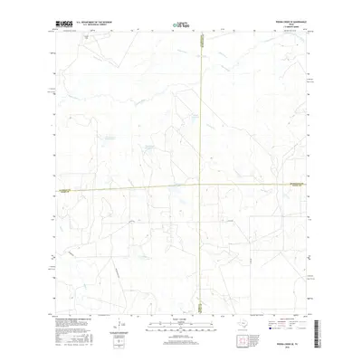
2016 Map of Piedra Creek SE
USGS Topo · Published 2016About this map
The Nueces River winds through this South Texas landscape where the borders of Webb, LaSalle, McMullen, and Duval counties meet. This ranchland terrain is defined by a network of seasonal drainages and creek beds, including the wide path of the Old Nueces River Channel and the namesake Piedra Creek. Local water management is evident in the presence of features like Arnold Lake Dam and several numbered catchments such as Charamusca Lake Number 7. While primarily open country, the map reveals the sparse infrastructure of the region via local routes like Withers Rd and the Gould Strip landing area. This survey provides a clear view of how land use and water resources were distributed across these county lines in the mid-2010s, capturing the various named creeks like Juanita Cr and Charamusca Cr that shape the local topography.
Find a feature on this map
20 named features on this map. Tap any name to fly to it.
Don’t see what you’re looking for? This feature index may not catch every label — zoom into the map to look around manually.
Map Details
Editions of this 2016 Piedra Creek SE Map
This is the sole edition of this map. No revisions or reprints were ever made.
Other maps of this area
1937 · Loma Alta
USGS Topo · 1:62,500

1953 · Crystal City
USGS Topo · 1:250,000

1955 · Crystal City
USGS Topo · 1:250,000
1956 · Freer
USGS Topo · 1:62,500
1956 · Piedra Creek
USGS Topo · 1:62,500
1956 · Las Mujeres
USGS Topo · 1:62,500

1956 · Laredo
USGS Topo · 1:250,000
1961 · Crystal City
USGS Topo · 1:250,000
1968 · Crystal City
USGS Topo · 1:250,000
1969 · Mirasol Creek
USGS Topo · 1:24,000