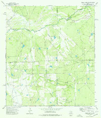
1974 Map of Piedra Creek SE
USGS Topo · Published 1977About this map
The Nueces River winds across this South Texas landscape where the borders of La Salle, McMullen, Webb, and Duval counties meet. In the mid-1970s, the region was defined by a dense network of energy infrastructure, most notably the Rodriguez Oil Field in the northwest and numerous Gas Wells scattered throughout the brush country. These industrial sites are linked by an intricate system of pipelines and unimproved roads that cut through the drainage basins of Piedra Creek and Charamusca Creek. Local history is anchored by the Adami Cem and a solitary Landing Strip, illustrating the combination of family heritage and the logistical needs of remote ranching and petroleum operations. The presence of a Flowing Well and several cattle tanks reflects the critical importance of water management in this arid environment.
Find a feature on this map
18 named features on this map. Tap any name to fly to it.
Don’t see what you’re looking for? This feature index may not catch every label — zoom into the map to look around manually.
Map Details
Editions of this 1974 Piedra Creek SE Map
This is the sole edition of this map. No revisions or reprints were ever made.
Other maps of this area

1937 · Loma Alta
USGS Topo · 1:62,500

1953 · Crystal City
USGS Topo · 1:250,000

1955 · Crystal City
USGS Topo · 1:250,000

1956 · Freer
USGS Topo · 1:62,500

1956 · Piedra Creek
USGS Topo · 1:62,500

1956 · Las Mujeres
USGS Topo · 1:62,500

1956 · Laredo
USGS Topo · 1:250,000

1961 · Crystal City
USGS Topo · 1:250,000

1968 · Crystal City
USGS Topo · 1:250,000
1969 · Mirasol Creek
USGS Topo · 1:24,000