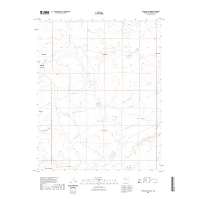
2023 Map of Piedra De La Aguila
USGS Topo · Published 2023About this map
Piedra de la Aguila rises as a prominent landmark in this high desert landscape of McKinley County, where seasonal hydrology dictates the naming of the terrain. The map reveals a complex network of ephemeral water sources and catchments, including Laguna Techillas, Laguna Huero, and Laguna Trujillo, which serve as vital markers in an otherwise arid expanse. These intermittent lakes and arroyos, such as the Arroyo Techillas and Arroyo Leon, trace the natural drainage patterns across the mesas. Large-scale topographic forms like Mesita Gato and Banco del Encierro define the local relief, while Cañon Largo and Mulatto Canyon carve deep recesses into the earth. The presence of Co RD 19 provides one of the few managed transportation corridors through this portion of the New Mexico interior, illustrating the sparse but deliberate infrastructure required to navigate this portion of the Colorado Plateau.
Find a feature on this map
24 named features on this map. Tap any name to fly to it.
Don’t see what you’re looking for? This feature index may not catch every label — zoom into the map to look around manually.
Map Details
Editions of this 2023 Piedra De La Aguila Map
This is the sole edition of this map. No revisions or reprints were ever made.
Other maps of this area

1883 · Mt. Taylor
USGS Topo · 1:250,000

1886 · Mt. Taylor
USGS Topo · 1:250,000

1892 · Mt. Taylor
USGS Topo · 1:250,000

1899 · Mt. Taylor
USGS Topo · 1:250,000

1957 · Ambrosia Lake
USGS Topo · 1:24,000

1958 · Albuquerque
USGS Topo · 1:250,000

1961 · El Dado
USGS Topo · 1:24,000

1961 · Piedra De La Aguila
USGS Topo · 1:24,000

1961 · Hospah
USGS Topo · 1:24,000
1961 · Mesita Americana
USGS Topo · 1:24,000