
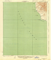
1927 Map of Piedras Blancas
USGS Topo · Published 1927About this map
Piedras Blancas Point anchors this coastal survey, serving as a critical navigational landmark on the California shore during the early twentieth century. The terrain is defined by short, steep drainages such as Arroyo de la Cruz and Arroyo del Corral that cut through the foothills of Pine Top Mtn before reaching the Pacific Ocean. This 1917 data, published in the late 1920s, shows the rural isolation of the San Luis Obispo coast before modern highway development.
Find a feature on this map
14 named features on this map. Tap any name to fly to it.
Don’t see what you’re looking for? This feature index may not catch every label — zoom into the map to look around manually.
Map Details
Editions of this 1927 Piedras Blancas Map
2 editions found
Other maps of this area

1919 · Bryson
USGS Topo · 1:62,500

1919 · Piedras Blancas
USGS Topo · 1:62,500

1919 · San Simeon
USGS Topo · 1:62,500

1921 · Cape San Martin
USGS Topo · 1:62,500

1937 · San Simeon
USGS Topo · 1:62,500

1941 · Cape San Martin
USGS Topo · 1:62,500

1941 · Bryson
USGS Topo · 1:62,500

1942 · Bryson
USGS Topo · 1:62,500

1942 · Cape San Martin
USGS Topo · 1:62,500

1947 · San Luis Obispo
USGS Topo · 1:250,000