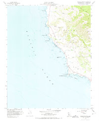
1959 Map of Piedras Blancas
USGS Topo · Published 1973About this map
Point Piedras Blancas serves as the focal point of this coastal survey, where the historic Lighthouse stands near the Coast Guard Res on the edge of the Pacific Ocean. This 1959 field check reveals a landscape dominated by the winding path of the Cabrillo Highway as it skirts the foothills of Piedra Blanca and Pine Top Mtn. The terrain is deeply incised by coastal drainage systems, including Arroyo de la Cruz and Arroyo del Corral, which carve canyons toward the rocky shoreline.
Find a feature on this map
24 named features on this map. Tap any name to fly to it.
Don’t see what you’re looking for? This feature index may not catch every label — zoom into the map to look around manually.
Map Details
Editions of this 1959 Piedras Blancas Map
3 editions found
Other maps of this area

1919 · Bryson
USGS Topo · 1:62,500

1919 · Piedras Blancas
USGS Topo · 1:62,500

1919 · San Simeon
USGS Topo · 1:62,500

1921 · Cape San Martin
USGS Topo · 1:62,500

1927 · Piedras Blancas
USGS Topo · 1:62,500

1937 · San Simeon
USGS Topo · 1:62,500

1941 · Cape San Martin
USGS Topo · 1:62,500

1941 · Bryson
USGS Topo · 1:62,500

1942 · Bryson
USGS Topo · 1:62,500

1942 · Cape San Martin
USGS Topo · 1:62,500