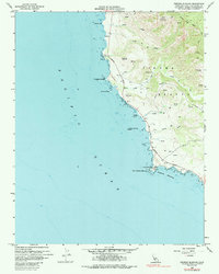
1959 Map of Piedras Blancas
USGS Topo · Published 1985About this map
Point Piedras Blancas anchors this stretch of the Central Coast, where the Lighthouse and Coast Guard Res stand at the edge of the Pacific Ocean. This 1959 survey records a landscape defined by sharp elevation changes, climbing from the tide line to the summit of Pine Top Mtn. The Cabrillo Highway serves as the primary artery, threading between the shore and the interior mountains while crossing drainage systems like Arroyo de la Cruz and Arroyo del Corral. Evidence of earlier resource extraction or land management appears at Cinnabar VABM 594, while the shoreline is dotted with distinct maritime landmarks including Pt Sierra Nevada and the offshore Harlech Castle Rock. The presence of several triangulation stations and a Gaging Station indicates the ongoing hydrographic and geodetic monitoring of this coastal reach during the mid-century.
Find a feature on this map
23 named features on this map. Tap any name to fly to it.
Don’t see what you’re looking for? This feature index may not catch every label — zoom into the map to look around manually.
Map Details
Editions of this 1959 Piedras Blancas Map
3 editions found
Other maps of this area

1919 · Bryson
USGS Topo · 1:62,500

1919 · Piedras Blancas
USGS Topo · 1:62,500

1919 · San Simeon
USGS Topo · 1:62,500

1921 · Cape San Martin
USGS Topo · 1:62,500

1927 · Piedras Blancas
USGS Topo · 1:62,500

1937 · San Simeon
USGS Topo · 1:62,500

1941 · Cape San Martin
USGS Topo · 1:62,500

1941 · Bryson
USGS Topo · 1:62,500

1942 · Bryson
USGS Topo · 1:62,500

1942 · Cape San Martin
USGS Topo · 1:62,500