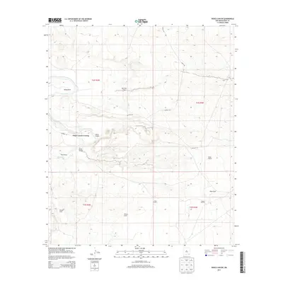
2013 Map of Pierce Canyon
USGS Topo · Published 2013About this map
Malaga Bend creates a distinct loop in the Pecos River as it snakes through this arid corner of Eddy County. The landscape is defined by a network of drainage features and human engineering, notably the Livingston Canal which runs parallel to the river's northern reach. Water management is a primary theme of the area, evidenced by the presence of isolated outposts like Carper Windmill and Tomcat Windmill situated among the dry washes. The topography is carved by several significant canyons and draws, including Pierce Canyon and Cedar Canyon, which feed toward the river valley. Transportation across this difficult terrain is facilitated by Pierce Canyon Crossing, a vital point of transit where the local road system meets the river. The map also reveals the rural grid of McDonald Rd and Gavilan Rd, which navigate around the natural depressions of Dog Town Draw and Pickett Draw.
Find a feature on this map
18 named features on this map. Tap any name to fly to it.
Don’t see what you’re looking for? This feature index may not catch every label — zoom into the map to look around manually.
Map Details
Editions of this 2013 Pierce Canyon Map
This is the sole edition of this map. No revisions or reprints were ever made.
Other maps of this area
1939 · Carlsbad
USGS Topo · 1:62,500
1939 · Nash Draw
USGS Topo · 1:62,500
1943 · Carlsbad
USGS Topo · 1:62,500
1943 · Nash Draw
USGS Topo · 1:62,500
1945 · Malaga
USGS Topo · 1:62,500
1946 · Malaga
USGS Topo · 1:62,500

1954 · Carlsbad
USGS Topo · 1:250,000

1954 · Hobbs
USGS Topo · 1:250,000

1958 · Carlsbad
USGS Topo · 1:250,000

1958 · Hobbs
USGS Topo · 1:250,000