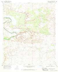
1968 Map of Pierce Canyon
USGS Topo · Published 1971About this map
The Pecos River loops sharply through this arid landscape of the Permian Basin, defining a region where water management and industrial extraction intersect. The winding river corridor is marked by the Malaga Bend and the Harroun Canal, reflecting an era of irrigation and ranching alongside emerging oil exploration. Steep-walled drainages like Pierce Canyon and Cedar Canyon cut across the limestone terrain, creating a complex topography of draws and mesas.
Find a feature on this map
23 named features on this map. Tap any name to fly to it.
Don’t see what you’re looking for? This feature index may not catch every label — zoom into the map to look around manually.
Map Details
Editions of this 1968 Pierce Canyon Map
This is the sole edition of this map. No revisions or reprints were ever made.
Other maps of this area

1939 · Carlsbad
USGS Topo · 1:62,500

1939 · Nash Draw
USGS Topo · 1:62,500

1943 · Carlsbad
USGS Topo · 1:62,500

1943 · Nash Draw
USGS Topo · 1:62,500

1945 · Malaga
USGS Topo · 1:62,500

1946 · Malaga
USGS Topo · 1:62,500

1954 · Carlsbad
USGS Topo · 1:250,000

1954 · Hobbs
USGS Topo · 1:250,000

1958 · Carlsbad
USGS Topo · 1:250,000

1958 · Hobbs
USGS Topo · 1:250,000