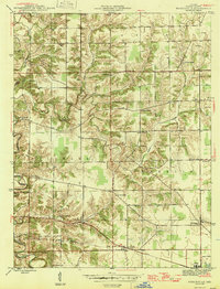
1946 Map of Pierceville
USGS Topo · Published 1946About this map
Laughery Creek and its many winding tributaries, including North Branch Laughery Creek and Ripley Creek, carve a deeply dissected landscape across this portion of Ripley County. The rugged topography is punctuated by rural crossroad settlements and family-named landmarks like Behmer Corner and Stumpke Corner. This mid-1940s survey highlights a dense network of country churches and burial grounds, such as the Adams Cem, St Nicholas Ch, and St Pauls Ch, which served the scattered farming communities of Adams and Franklin townships.
Find a feature on this map
23 named features on this map. Tap any name to fly to it.
Don’t see what you’re looking for? This feature index may not catch every label — zoom into the map to look around manually.
Map Details
Editions of this 1946 Pierceville Map
2 editions found
Other maps of this area

1946 · Versailles
USGS Topo · 1:24,000

1946 · Milan
USGS Topo · 1:24,000

1946 · Pierceville
USGS Topo · 1:24,000

1946 · Batesville
USGS Topo · 1:24,000

1946 · Osgood
USGS Topo · 1:24,000

1946 · New Point
USGS Topo · 1:24,000

1953 · Cincinnati
USGS Topo · 1:250,000

1957 · Cincinnati
USGS Topo · 1:250,000

1958 · Spades
USGS Topo · 1:24,000

1958 · Sunman
USGS Topo · 1:24,000