
1946 Map of New Point
USGS Topo · Published 1946About this map
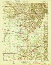
The New Point rail stop on the New York Central serves as the central hub of this mid-century rural landscape, straddling the line between Decatur and Franklin counties. The map captures a transition in transport and land use, where the high-speed rail corridor bisects a terrain defined by older, meandering waterways like Salt Creek and Laughery Creek. Small, distinct communities such as St Maurice and Enochsburg anchor the northern reaches, while the southern portion of the quadrangle is marked by isolated landmarks of rural social life, including New Pennington Ch and the Pocket Sch. The dense contour lines near the creek forks suggest a dissected landscape that constrained the straight-line development of early roads, forcing a patchwork of farm-to-market routes that still connected these family-named school districts and parish churches.
Find a feature on this map
22 named features on this map. Tap any name to fly to it.
Don’t see what you’re looking for? This feature index may not catch every label — zoom into the map to look around manually.
Map Details
Editions of this 1946 New Point Map
2 editions found
Other maps of this area

1946 · Pierceville
USGS Topo · 1:24,000

1946 · Batesville
USGS Topo · 1:24,000

1946 · Osgood
USGS Topo · 1:24,000

1953 · Cincinnati
USGS Topo · 1:250,000

1956 · Metamora
USGS Topo · 1:24,000

1957 · Cincinnati
USGS Topo · 1:250,000

1958 · Greensburg
USGS Topo · 1:24,000

1958 · Millhousen
USGS Topo · 1:24,000

1958 · Clarksburg
USGS Topo · 1:24,000

1959 · Milroy
USGS Topo · 1:24,000