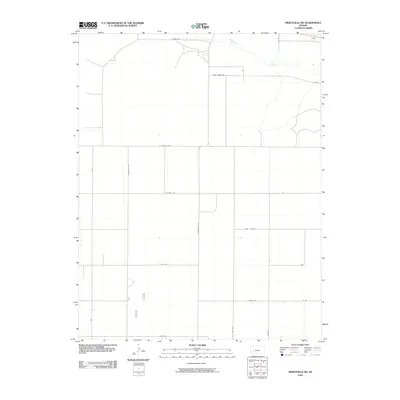
2009 Map of Pierceville SW
USGS Topo · Published 2009About this map
The Arkansas River cuts across the northern edge of this Finney County landscape, serving as a primary geographical anchor for an area defined by its systematic agricultural grid. Surveyed in the early 21st century, the terrain is partitioned by a network of rural routes that reflect local land use and property boundaries. Many of these roads bear names of potential genealogical interest, such as Annie Sheer Rd, while others follow a coordinated system including E Plymell Rd and S Pierceville Rd. The map illustrates the transition from the river valley to the expansive plains of western Kansas, where transportation relies on long, straight thoroughfares like E Parallel Rd and S Beefland Rd.
Find a feature on this map
17 named features on this map. Tap any name to fly to it.
Don’t see what you’re looking for? This feature index may not catch every label — zoom into the map to look around manually.
Map Details
Editions of this 2009 Pierceville SW Map
This is the sole edition of this map. No revisions or reprints were ever made.
Other maps of this area

1896 · Garden
USGS Topo · 1:125,000

1955 · Dodge City
USGS Topo · 1:250,000

1958 · Dodge City
USGS Topo · 1:250,000

1959 · Dodge City
USGS Topo · 1:250,000

1959 · Garden City 3 NE
USGS Topo · 1:24,000

1960 · Garden City East
USGS Topo · 1:24,000

1960 · Plymell
USGS Topo · 1:24,000

1967 · Pierceville SW
USGS Topo · 1:24,000

1967 · Pierceville
USGS Topo · 1:24,000
1968 · Charleston
USGS Topo · 1:24,000