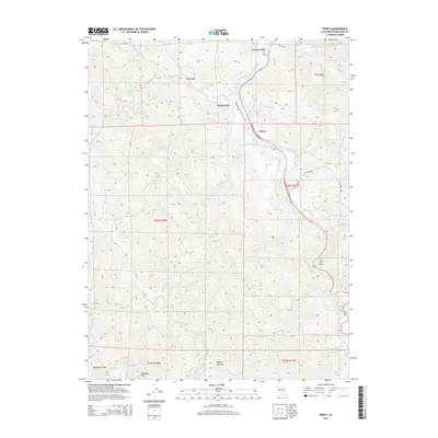
2015 Map of Piercy
USGS Topo · Published 2015About this map
The South Fork Eel River winds through this Mendocino County landscape, serving as the central artery for the small communities of Piercy, Andersonia, and Cooks Valley. This 2015 topography shows a complex network of canyons and drainage systems defined by Indian Cr and Standley Cr. Significant for genealogists and local historians, the Lilley Grave Cemetery is documented on the eastern slopes above the river, while locations like Dugans Opening and the prominent Chimney Rock in the southwest corner serve as key geographical markers. The map reflects a region where winding forest roads like Red Mountain Rd and Shamrock Rd connect isolated clearings and steep terrain, illustrating the modern rural character of northern California's timber and river country.
Find a feature on this map
37 named features on this map. Tap any name to fly to it.
Don’t see what you’re looking for? This feature index may not catch every label — zoom into the map to look around manually.
Map Details
Editions of this 2015 Piercy Map
This is the sole edition of this map. No revisions or reprints were ever made.
Other maps of this area
1920 · Cummings
USGS Topo · 1:62,500
1920 · Harris
USGS Topo · 1:62,500
1921 · Briceland
USGS Topo · 1:62,500
1949 · Alderpoint
USGS Topo · 1:62,500
1949 · Garberville
USGS Topo · 1:62,500
1950 · Piercy
USGS Topo · 1:62,500
1951 · Alderpoint
USGS Topo · 1:62,500
1951 · Garberville
USGS Topo · 1:62,500
1952 · Leggett
USGS Topo · 1:62,500
1957 · Ukiah
USGS Topo · 1:250,000