
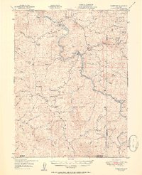
1951 Map of Alderpoint
USGS Topo · Published 1951About this map
The Northwestern Pacific Railroad snakes along the banks of the Eel River in this mid-century portrait of southern Humboldt County. This steep, dissected terrain is defined by its isolated settlements and ranching outposts, including Fort Seward in the north and Alderpoint further downstream. The presence of a Lumber Mill near Alderpoint and the Blocksburg Ranger Sta highlights the region's reliance on timber and forest management within the Six Rivers National Forest. Genealogists will find a wealth of family-named landmarks and homesteads, such as the Miller Ranch, Ware Ranch, and Lauford Ranch, which reveal the pattern of settlement along the numerous creek forks. The map also identifies the Harris PO and Steelhead, providing a clear record of the rural infrastructure and small communities that served this rugged portion of the California Coast Ranges before later modernization changed the local landscape.
Find a feature on this map
54 named features on this map. Tap any name to fly to it.
Don’t see what you’re looking for? This feature index may not catch every label — zoom into the map to look around manually.
Map Details
Editions of this 1951 Alderpoint Map
2 editions found
Other maps of this area

1918 · Anada
USGS Topo · 1:62,500

1920 · Cummings
USGS Topo · 1:62,500

1920 · Covelo
USGS Topo · 1:62,500

1920 · Harris
USGS Topo · 1:62,500

1921 · Dyerville
USGS Topo · 1:62,500

1921 · Briceland
USGS Topo · 1:62,500

1921 · Hoaglin
USGS Topo · 1:62,500

1922 · Island Mountain
USGS Topo · 1:62,500

1931 · Hoaglin
USGS Topo · 1:96,000

1935 · Hoaglin
USGS Topo · 1:125,000