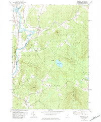
1979 Map of Piermont
USGS Topo · Published 1984About this map
The Connecticut River serves as the dividing line between New Hampshire and Vermont in this late 1970s survey, anchoring a landscape where river-valley agriculture meets steep upland terrain. The village of Piermont sits at the confluence of Eastman Brook and the river, flanked by historical burial grounds including Cedar Grove Cem and South Lawn Cem. Further south, the map details the rural character of Orford and Piermont townships, where small settlements like Archertown and Orfordville are connected by winding mountain roads and the prominent Boston and Maine railroad line running along the Vermont shore through Bradford and Lower Plain.
Find a feature on this map
42 named features on this map. Tap any name to fly to it.
Don’t see what you’re looking for? This feature index may not catch every label — zoom into the map to look around manually.
Map Details
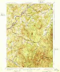
Editions of this 1979 Piermont Map
2 editions found

Other maps of this area

1928 · Rumney
USGS Topo · 1:62,500

1929 · Moosilauke
USGS Topo · 1:62,500

1931 · Mt. Cube
USGS Topo · 1:62,500

1931 · Woodsville
USGS Topo · 1:48,000

1932 · Rumney
USGS Topo · 1:62,500
1932 · Moosilauke
USGS Topo · 1:62,500

1933 · Mt. Cube
USGS Topo · 1:62,500

1935 · Woodsville
USGS Topo · 1:62,500

1941 · Woodsville
USGS Topo · 1:62,500

1949 · Portland
USGS Topo · 1:250,000