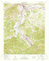
1956 Map of Pigeon Forge
USGS Topo · Published 1973About this map
Sevierville serves as the northern anchor of this landscape, situated at the confluence where the Little Pigeon River meets its forks. The terrain transitions from the river bottoms to the steep, wooded slopes of Pine Mountain and Walden Ridge in the south. The development pattern reflects a transition period in the mid-20th century, with the expansion of Pigeon Forge visible along the West Prong Little Pigeon River. Purple revisions from 1970 illustrate the early growth of tourism infrastructure, including the Gatlinburg Golf Course and the Sevier-Gatlinburg Airport.
Find a feature on this map
75 named features on this map. Tap any name to fly to it.
Don’t see what you’re looking for? This feature index may not catch every label — zoom into the map to look around manually.
Map Details
Editions of this 1956 Pigeon Forge Map
3 editions found
Other maps of this area

1886 · Knoxville
USGS Topo · 1:125,000

1892 · Knoxville
USGS Topo · 1:125,000

1893 · Mt Guyot
USGS Topo · 1:125,000

1894 · Knoxville
USGS Topo · 1:125,000

1895 · Knoxville
USGS Topo · 1:125,000

1901 · Knoxville
USGS Topo · 1:125,000

1912 · Mt Guyot
USGS Topo · 1:125,000

1935 · English Mountain
USGS Topo · 1:48,000

1935 · Walden Creek
USGS Topo · 1:24,000

1935 · Richardson Cove
USGS Topo · 1:24,000