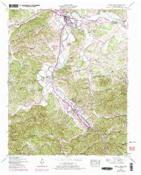
1956 Map of Pigeon Forge
USGS Topo · Published 1973About this map
Sevierville and the nascent resort community of Pigeon Forge occupy the heart of this Sevier County survey, which documents the region's mid-century transition from mountain farming to a recreation-based economy. The landscape is dominated by the Little Pigeon River and its major tributaries, the West Prong and Middle Prong, which carve through the ridges of Pine Mountain and Patterson Ridge. This 1956 edition, with 1970 photo-revisions, captures the early footprint of modern landmarks like the Sevier-Gatlinburg Airport and the Gatlinburg Golf Course alongside traditional mountain institutions.
Find a feature on this map
66 named features on this map. Tap any name to fly to it.
Don’t see what you’re looking for? This feature index may not catch every label — zoom into the map to look around manually.
Map Details
Editions of this 1956 Pigeon Forge Map
3 editions found
Other maps of this area

1886 · Knoxville
USGS Topo · 1:125,000

1892 · Knoxville
USGS Topo · 1:125,000

1893 · Mt Guyot
USGS Topo · 1:125,000

1894 · Knoxville
USGS Topo · 1:125,000

1895 · Knoxville
USGS Topo · 1:125,000

1901 · Knoxville
USGS Topo · 1:125,000

1912 · Mt Guyot
USGS Topo · 1:125,000

1935 · English Mountain
USGS Topo · 1:48,000

1935 · Walden Creek
USGS Topo · 1:24,000

1935 · Richardson Cove
USGS Topo · 1:24,000