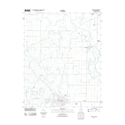
2011 Map of Piggott
USGS Topo · Published 2011About this map
Piggott and the winding Saint Francis River define this corner of Northeast Arkansas, where the flatlands of the Mississippi embayment meet the distinct elevation of Crowleys Ridge. The landscape is a network of drainage and small watercourses like McNie Creek, Horse Creek, and Sugar Creek, supporting a predominantly agricultural region. Cultural landmarks such as the Clay County Fairgrounds and Piggott Post Office serve as focal points for the local community, while family-named sites like McElyea Place and Whitaker Place provide valuable clues for genealogical research.
Find a feature on this map
76 named features on this map. Tap any name to fly to it.
Don’t see what you’re looking for? This feature index may not catch every label — zoom into the map to look around manually.
Map Details
Editions of this 2011 Piggott Map
This is the sole edition of this map. No revisions or reprints were ever made.
Other maps of this area

1935 · Rector
USGS Topo · 1:62,500

1935 · Harviell
USGS Topo · 1:62,500

1940 · Valley Ridge
USGS Topo · 1:62,500

1940 · Piggott
USGS Topo · 1:62,500

1956 · Valley Ridge
USGS Topo · 1:62,500

1956 · Piggott
USGS Topo · 1:62,500

1957 · Poplar Bluff
USGS Topo · 1:250,000

1958 · Rector
USGS Topo · 1:62,500

1959 · Poplar Bluff
USGS Topo · 1:250,000
1960 · Rector
USGS Topo · 1:62,500