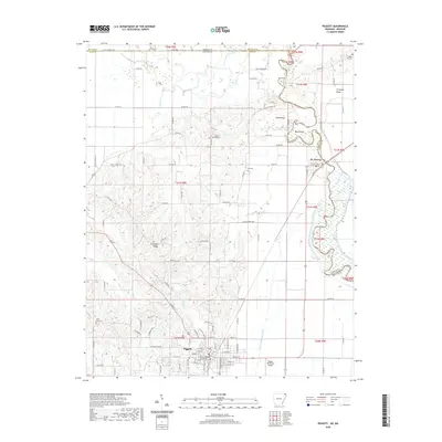
2020 Map of Piggott
USGS Topo · Published 2020About this map
The Clay County Courthouse Eastern District serves as the focal point for the city of Piggott, situated in the northeastern corner of Arkansas along the Missouri border. The landscape is defined by the geological rise of Crowleys Ridge, which provides a distinct elevation contrast to the low-lying wetlands and drainage networks to the east. Several local burial sites, including Rocky Hill Cem, Gravel Hill Cem, and Little Flock Cem, are scattered across the terrain, reflecting the long-standing rural community structure of Clay County.
Find a feature on this map
68 named features on this map. Tap any name to fly to it.
Don’t see what you’re looking for? This feature index may not catch every label — zoom into the map to look around manually.
Map Details
Editions of this 2020 Piggott Map
This is the sole edition of this map. No revisions or reprints were ever made.
Other maps of this area

1935 · Rector
USGS Topo · 1:62,500

1935 · Harviell
USGS Topo · 1:62,500

1940 · Valley Ridge
USGS Topo · 1:62,500

1940 · Piggott
USGS Topo · 1:62,500

1956 · Valley Ridge
USGS Topo · 1:62,500

1956 · Piggott
USGS Topo · 1:62,500

1957 · Poplar Bluff
USGS Topo · 1:250,000

1958 · Rector
USGS Topo · 1:62,500

1959 · Poplar Bluff
USGS Topo · 1:250,000
1960 · Rector
USGS Topo · 1:62,500