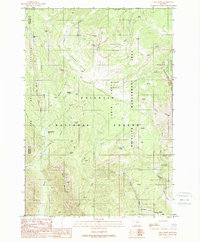
1988 Map of Pika Point
USGS Topo · Published 1989About this map
The Lee Metcalf Wilderness and Gallatin National Forest dominate this high-altitude landscape along the border of Madison and Gallatin counties. This 1980s provisional map details an alpine environment defined by glacial basins and numerous small lakes named for their botanical and geological traits, including Potamogeton Park, Axolotl Lake, and Turquoise Lake. The drainage network is complex, with Beaver Creek and the Middle Fork of Cabin Creek carving through the terrain. The presence of the Cabin Creek Wildlife Management Area and the Carrot Basin indicates a region managed for both ecological preservation and wildlife habitat during the late twentieth century. Notable landmarks such as Apex Point and Lookout Point offer orientation points across the high Sage Basin and along the Skyline Ridge.
Find a feature on this map
26 named features on this map. Tap any name to fly to it.
Don’t see what you’re looking for? This feature index may not catch every label — zoom into the map to look around manually.
Map Details
Editions of this 1988 Pika Point Map
2 editions found
Other maps of this area

1888 · Three Forks
USGS Topo · 1:250,000

1894 · Three Forks
USGS Topo · 1:250,000

1895 · Three Forks
USGS Topo · 1:250,000

1947 · Bozeman
USGS Topo · 1:250,000

1948 · Bozeman
USGS Topo · 1:250,000

1950 · Hebgen Dam
USGS Topo · 1:62,500

1950 · Sphinx Mountain
USGS Topo · 1:62,500

1955 · Bozeman
USGS Topo · 1:250,000

1955 · Crown Butte
USGS Topo · 1:62,500

1955 · Ashton
USGS Topo · 1:250,000