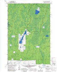
1971 Map of Pike Lake SW
USGS Topo · Published 1985About this map
Chequamegon National Forest dominates this landscape in the early 1970s, defined by its complex network of wetlands and conservation zones. The terrain is marked by significant hydrological features such as the central Wilson Flowage and the northern Riley Lake, which is surrounded by the dedicated Riley Lake Wildlife Management Area. These protected lands illustrate a focused era of Northwoods conservation and forest management under the Park Falls Ranger District. The map reveals a wilder character of Price County, where managed tracts like the Schmuland Waterfowl Area were prioritized for habitat protection. Waterways including the Elk River and Spring Creek wind through the forest, while small Gravel Pit locations suggest the local materials used to maintain routes like Riley Lake Road.
Find a feature on this map
15 named features on this map. Tap any name to fly to it.
Don’t see what you’re looking for? This feature index may not catch every label — zoom into the map to look around manually.
Map Details
Editions of this 1971 Pike Lake SW Map
3 editions found
Other maps of this area

1941 · Park Falls
USGS Topo · 1:48,000

1941 · Pike Lake
USGS Topo · 1:48,000

1941 · Phillips
USGS Topo · 1:48,000

1941 · Brantwood
USGS Topo · 1:48,000

1942 · Pike Lake
USGS Topo · 1:48,000

1943 · Park Falls
USGS Topo · 1:48,000

1943 · Philliips
USGS Topo · 1:48,000

1943 · Brantwood
USGS Topo · 1:48,000

1947 · Park Falls
USGS Topo · 1:48,000

1950 · Pike Lake
USGS Topo · 1:48,000