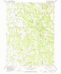
1978 Map of Pike Mountain
USGS Topo · Published 1978About this map
Pike Mountain and the high ridges of the Sawtooth National Forest dominate this 1970s landscape along the border of Twin Falls and Cassia Counties. The area is defined by its recreation and forestry infrastructure, notably the Magic Mtn Ski Area and several remote outposts like the Shoshone Forest Service Station and Rock Creek Ranger Station. The map captures a high-elevation environment characterized by a dense network of water sources such as Electric Spring, Lava Spring, and Shoshone Spring, which support the livestock and wildlife of the region.
Find a feature on this map
91 named features on this map. Tap any name to fly to it.
Don’t see what you’re looking for? This feature index may not catch every label — zoom into the map to look around manually.
Map Details
Editions of this 1978 Pike Mountain Map
2 editions found
Other maps of this area

1955 · Twin Falls
USGS Topo · 1:250,000

1958 · Twin Falls
USGS Topo · 1:250,000

1965 · Rams Horn Ridge
USGS Topo · 1:24,000

1965 · Grand View Peak
USGS Topo · 1:24,000

1965 · Mc Mullen Basin
USGS Topo · 1:24,000

1977 · Timber Butte
USGS Topo · 1:24,000

1977 · Big Creek Ranch
USGS Topo · 1:24,000

1977 · Mahogany Butte
USGS Topo · 1:24,000

1978 · Hopper Gulch
USGS Topo · 1:24,000
1979 · Trapper Peak
USGS Topo · 1:24,000