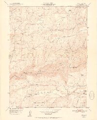
1951 Map of Pike
USGS Topo · Published 1951About this map
Malakoff Diggings and the hydraulic mining history of the Sierra Nevada foothills dominate this 1951 survey, which captures the landscape at the boundary of Sierra and Nevada counties. The map traces the rugged divide of Pliocene Ridge and San Juan Ridge, where extensive gold-bearing gravels led to the development of numerous mining operations. Evidence of this extraction era is scattered across the terrain, from the True Grit Mine (Site) and Alaska Mine (Site) to the Kate Hardy Mine. Small residential clusters and agricultural outposts like Pike, North Columbia, and Gales Orchard provide a glimpse into the localized economies that persisted long after the peak of the gold rush. The course of the Middle Yuba River and its deeply incised tributaries, including Kanaka Creek and Oregon Creek, define the complex topography that constrained travel to high ridges and established trails.
Find a feature on this map
101 named features on this map. Tap any name to fly to it.
Don’t see what you’re looking for? This feature index may not catch every label — zoom into the map to look around manually.
Map Details
Editions of this 1951 Pike Map
2 editions found
Other maps of this area

1888 · Smartsville
USGS Topo · 1:125,000

1888 · Bidwell Bar
USGS Topo · 1:125,000

1891 · Bidwell Bar
USGS Topo · 1:125,000

1891 · Downieville
USGS Topo · 1:125,000

1891 · Colfax
USGS Topo · 1:125,000

1891 · Smartsville
USGS Topo · 1:125,000

1892 · Smartsville
USGS Topo · 1:125,000

1892 · Colfax
USGS Topo · 1:125,000

1893 · Bidwell Bar
USGS Topo · 1:125,000

1893 · Downieville
USGS Topo · 1:125,000