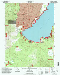
1995 Map of Pikes Point
USGS Topo · Published 1998About this map
Eagle Lake dominates the eastern portion of this northern California survey, reflecting the recreational and forest management landscape of the mid-1990s. The shoreline is punctuated by development at the Eagle Lake Resort and the Gallatin House, alongside public facilities like the Amphitheater Information Center and several boat ramps. This era shows a focus on conservation and public access within the Lassen National Forest, noted by the presence of the Osprey Management Area along the northern coast. Inland, the terrain transitions from the water's edge to the timbered slopes of Merrill Mountain and the open expanses of Big Merrill Flat. Evidence of the region's environmental history is visible in the documented Eagle Lake Burn and Gallatin Burn, while local landmarks like the Lower Brockman Flat Landing Strip and Roney Corral indicate the varied uses of these highland forests.
Find a feature on this map
40 named features on this map. Tap any name to fly to it.
Don’t see what you’re looking for? This feature index may not catch every label — zoom into the map to look around manually.
Map Details
Editions of this 1995 Pikes Point Map
This is the sole edition of this map. No revisions or reprints were ever made.
Other maps of this area

1886 · Honey Lake
USGS Topo · 1:250,000

1891 · Honey Lake
USGS Topo · 1:250,000

1893 · Honey Lake
USGS Topo · 1:250,000

1954 · Susanville
USGS Topo · 1:62,500

1954 · Fredonyer Peak
USGS Topo · 1:62,500

1955 · Westwood
USGS Topo · 1:62,500

1955 · Westwood
USGS Topo · 1:250,000

1956 · Antelope Mtn
USGS Topo · 1:62,500

1958 · Westwood
USGS Topo · 1:250,000

1959 · Westwood
USGS Topo · 1:250,000