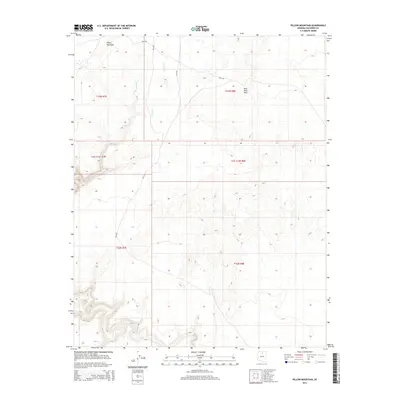
2014 Map of Pillow Mountain
USGS Topo · Published 2014About this map
Pillow Mountain rises as the dominant landmark in this high-desert landscape within Coconino County. The terrain is defined by a series of drainage systems, most notably Sheep Wash and Dry Wash, which cut through the arid topography. This 2014 survey reveals a transition from the elevated Red Point Hills toward more level territory to the south and west. The area is interlaced with a network of Bureau of Indian Affairs routes, including Bia-6130 and Bia-6133, which serve as the primary conduits for travel and land management across these remote sections. The map preserves the specific township and range grid, showing the relationship between these administrative lines and the natural contours of the Arizona desert.
Find a feature on this map
14 named features on this map. Tap any name to fly to it.
Don’t see what you’re looking for? This feature index may not catch every label — zoom into the map to look around manually.
Map Details
Editions of this 2014 Pillow Mountain Map
This is the sole edition of this map. No revisions or reprints were ever made.
Other maps of this area

1886 · Echo Cliffs
USGS Topo · 1:250,000

1891 · Echo Cliffs
USGS Topo · 1:250,000

1954 · Shinumo Altar SE
USGS Topo · 1:24,000

1954 · Shinumo Altar
USGS Topo · 1:62,500

1955 · Blue Spring NE
USGS Topo · 1:24,000
1955 · Blue Spring SE
USGS Topo · 1:24,000

1955 · Moa Ave NW
USGS Topo · 1:24,000
1955 · Moa Ave SW
USGS Topo · 1:24,000

1955 · Blue Spring
USGS Topo · 1:62,500

1956 · Marble Canyon
USGS Topo · 1:250,000