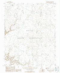
1988 Map of Pillow Mountain
USGS Topo · Published 1988About this map
The Navajo Indian Reservation covers this high-desert landscape in northern Arizona, where the topography is defined by intricate drainage systems and prominent landmarks. The namesake Pillow Mountain rises in the northwest, overlooking a network of seasonal watercourses including Sheep Wash and Dry Wash. To the east, the Red Point Hills provide significant vertical relief, while the southern portion of the sheet is dominated by the deep incisions of Big Canyon. Settlement is sparse in this era, represented only by isolated infrastructure such as a Corral, illustrating the remote nature of the terrain and its primary use for livestock grazing within the reservation boundaries. This 1988 provisional edition emphasizes the natural landforms and the arid geography of Coconino County before modern development reached the area.
Find a feature on this map
7 named features on this map. Tap any name to fly to it.
Don’t see what you’re looking for? This feature index may not catch every label — zoom into the map to look around manually.
Map Details
Editions of this 1988 Pillow Mountain Map
This is the sole edition of this map. No revisions or reprints were ever made.
Other maps of this area

1886 · Echo Cliffs
USGS Topo · 1:250,000

1891 · Echo Cliffs
USGS Topo · 1:250,000

1954 · Shinumo Altar SE
USGS Topo · 1:24,000

1954 · Shinumo Altar
USGS Topo · 1:62,500

1955 · Blue Spring NE
USGS Topo · 1:24,000
1955 · Blue Spring SE
USGS Topo · 1:24,000

1955 · Moa Ave NW
USGS Topo · 1:24,000
1955 · Moa Ave SW
USGS Topo · 1:24,000

1955 · Blue Spring
USGS Topo · 1:62,500

1956 · Marble Canyon
USGS Topo · 1:250,000