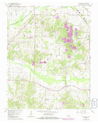
1967 Map of Pillowville
USGS Topo · Published 1985About this map
Pillowville and Gleason anchor this mid-century portrait of Weakley County, where the agricultural landscape meets an industrializing clay industry. The Seaboard railroad cuts through the northeast corner, supporting the local economy alongside numerous Claypits and Claypit operations that dot the central and northern terrain. The Middle Fk Obion River meanders across the top of the sheet, fed by a dense network of local waterways including Spring Creek and Cane Creek.
Find a feature on this map
30 named features on this map. Tap any name to fly to it.
Don’t see what you’re looking for? This feature index may not catch every label — zoom into the map to look around manually.
Map Details
Editions of this 1967 Pillowville Map
3 editions found
Other maps of this area

1950 · Martin
USGS Topo · 1:24,000

1952 · Dresden
USGS Topo · 1:24,000

1954 · Greenfield
USGS Topo · 1:24,000

1954 · Bradford
USGS Topo · 1:24,000

1956 · Dyersburg
USGS Topo · 1:250,000

1957 · Como
USGS Topo · 1:24,000

1966 · Trezevant West
USGS Topo · 1:24,000

1967 · Pillowville
USGS Topo · 1:24,000
1967 · Trezevant East
USGS Topo · 1:24,000
1967 · Mc Kenzie
USGS Topo · 1:24,000