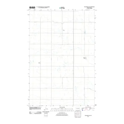
2011 Map of Pillsbury SE
USGS Topo · Published 2011About this map
Morton Cemetery sits near the intersection of 127th Ave SE and 22nd St SE, serving as a primary point of local history in this rural landscape. This part of North Dakota is defined by a grid-like network of roads such as 21st St SE and 129th Ave SE that segment the prairie into large agricultural tracts. The terrain is marked by significant natural and modified features, including the waters of Minnie Lake and the prominent rise of Pilot Knob. Aviation's role in the regional farming economy is highlighted by the Gage Flying Farmer Landing Strip, a specialized airfield located along 129th Ave SE that underscores the scale of modern agricultural operations in this corner of the state.
Find a feature on this map
17 named features on this map. Tap any name to fly to it.
Don’t see what you’re looking for? This feature index may not catch every label — zoom into the map to look around manually.
Map Details
Editions of this 2011 Pillsbury SE Map
This is the sole edition of this map. No revisions or reprints were ever made.
Other maps of this area

1897 · Tower
USGS Topo · 1:125,000

1952 · Grand Forks
USGS Topo · 1:250,000

1953 · Fargo
USGS Topo · 1:250,000

1956 · Fargo
USGS Topo · 1:250,000

1956 · Grand Forks
USGS Topo · 1:250,000

1961 · Valley City East
USGS Topo · 1:24,000

1966 · Grand Forks
USGS Topo · 1:250,000

1967 · Tower City
USGS Topo · 1:24,000

1967 · Pillsbury SE
USGS Topo · 1:24,000
1967 · Pillsbury SW
USGS Topo · 1:24,000
Featured Places
- Noltimier Township, ND
- Grand Prairie Township, ND
- Minnie Lake Township, ND
- Weimer Township, ND
- Barnes County, ND