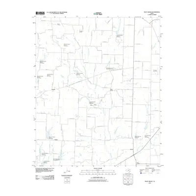
2010 Map of Pilot Grove
USGS Topo · Published 2010About this map
Small rural communities and a sophisticated network of flood control structures define this pocket of North Texas in the early 21st century. The map centers on Pilot Grove and Desert, alongside smaller clusters at Cannon and Sedalia. The landscape is heavily managed by the Soil Conservation Service, which maintained numerous dams across the drainage basins of Pilot Grove Creek and its tributaries, including Soil Conservation Service Site 10 Dam and Soil Conservation Service Site 38 Dam. For genealogists and local historians, several burial grounds are preserved, such as the Worden Cemetery in the north and the Desert Cemetery to the south. Transportation and aviation are represented by the Rowland R Airfield and the Tri-County Aerodrome, reflecting the region's low-density, agricultural character and continued reliance on local airstrips and farm-to-market roads like FM 2729.
Find a feature on this map
104 named features on this map. Tap any name to fly to it.
Don’t see what you’re looking for? This feature index may not catch every label — zoom into the map to look around manually.
Map Details
Editions of this 2010 Pilot Grove Map
This is the sole edition of this map. No revisions or reprints were ever made.
Other maps of this area

1901 · Denison
USGS Topo · 1:125,000

1954 · Sherman
USGS Topo · 1:250,000

1958 · Whitesright
USGS Topo · 1:62,500

1958 · Sherman
USGS Topo · 1:250,000

1958 · Sherman
USGS Topo · 1:62,500

1958 · Howe
USGS Topo · 1:24,000

1960 · Blue Ridge
USGS Topo · 1:24,000

1960 · Pike
USGS Topo · 1:24,000

1961 · Van Alstyne
USGS Topo · 1:24,000
1961 · Anna
USGS Topo · 1:24,000