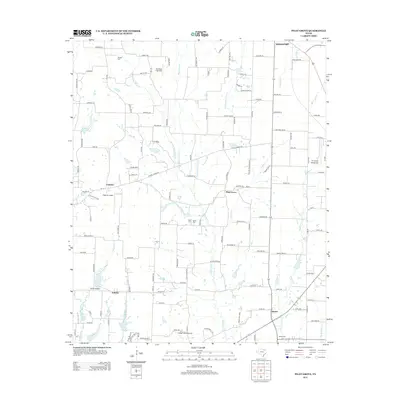
2013 Map of Pilot Grove
USGS Topo · Published 2013About this map
The agrarian landscape of North Texas unfolds across this 2013 survey, anchored by the historic crossroads of Whitewright and the namesake community of Pilot Grove. This region of Grayson County is defined by its intricate network of rural roads and the drainage systems of Pilot Grove Cr and Wolf Run Cr. Genealogists and local historians can locate several family and community burial grounds, including Worden Cem, Luper Cem, and Binion Cem, which are tucked away near established homesteads and creek beds. Small-scale aviation is a notable characteristic of the area, as evidenced by several private landing strips like the Rowland R Airfield, Tilghman Airport, and the Tri-county Aerodrome. The map captures the quiet persistence of rural settlements such as Cannon, Sedalia, and Desert, where the traditional Texas landscape remains largely intact despite the modernization of the surrounding road network.
Find a feature on this map
72 named features on this map. Tap any name to fly to it.
Don’t see what you’re looking for? This feature index may not catch every label — zoom into the map to look around manually.
Map Details
Editions of this 2013 Pilot Grove Map
This is the sole edition of this map. No revisions or reprints were ever made.
Other maps of this area

1901 · Denison
USGS Topo · 1:125,000

1954 · Sherman
USGS Topo · 1:250,000

1958 · Whitesright
USGS Topo · 1:62,500

1958 · Sherman
USGS Topo · 1:250,000

1958 · Sherman
USGS Topo · 1:62,500

1958 · Howe
USGS Topo · 1:24,000

1960 · Blue Ridge
USGS Topo · 1:24,000

1960 · Pike
USGS Topo · 1:24,000

1961 · Van Alstyne
USGS Topo · 1:24,000
1961 · Anna
USGS Topo · 1:24,000