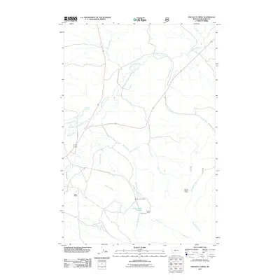
2011 Map of Pinchout Creek
USGS Topo · Published 2011About this map
North Fork Smith River flows through this corner of Meagher County, where the landscape is defined by the intersection of mountain ranching and small-scale resource extraction. The area's industrial history is marked by several named workings, including the Ringling Mine and Cut Bank Mine situated near the Willow Creek Reservoir. These features, along with other numbered operations like the NW NW Section 19 Mine, point to a legacy of mineral prospecting in the shadow of the Little Belt and Castle Mountains. Water management is a primary theme of the landscape, evident in the system of drainage from Pinchout Creek and the presence of the South Side Canal, which supports the agricultural demands of local outfits like the Castle Mountain Ranch. The terrain rises toward Clay Butte in the southwest, while a network of rural roads like Zehntner Ln and NFD Rd 211 provide access to the high country.
Find a feature on this map
24 named features on this map. Tap any name to fly to it.
Don’t see what you’re looking for? This feature index may not catch every label — zoom into the map to look around manually.
Map Details
Editions of this 2011 Pinchout Creek Map
This is the sole edition of this map. No revisions or reprints were ever made.
Other maps of this area

1886 · Little Belt Mts.
USGS Topo · 1:250,000

1894 · Little Belt Mts.
USGS Topo · 1:250,000

1897 · Little Belt Mts.
USGS Topo · 1:250,000

1898 · Little Belt Mts.
USGS Topo · 1:250,000

1902 · Little Belt Mts.
USGS Topo · 1:250,000

1948 · White Sulphur Springs
USGS Topo · 1:250,000

1958 · White Sulphur Springs
USGS Topo · 1:250,000

1961 · White Sulphur Springs
USGS Topo · 1:250,000

1965 · White Sulphur Springs
USGS Topo · 1:250,000
1971 · White Sulphur Springs
USGS Topo · 1:24,000