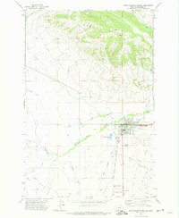
1971 Map of White Sulphur Springs
USGS Topo · Published 1974About this map
The county seat of White Sulphur Springs is the focal point of this 1971 survey, where the White Sulphur Springs and Yellowstone Park Railway terminates near the town's western edge. This rail connection and the presence of the Mill Siding reflect the local industry, while the Rodeo Ground and the White Sulphur Springs Airport mark the community's mid-century expansion. The town is flanked by the Park Hills to the north and the winding Smith River to the southwest, creating a distinct geographic profile for the era.
Find a feature on this map
28 named features on this map. Tap any name to fly to it.
Don’t see what you’re looking for? This feature index may not catch every label — zoom into the map to look around manually.
Map Details
Editions of this 1971 White Sulphur Springs Map
This is the sole edition of this map. No revisions or reprints were ever made.
Other maps of this area

1886 · Fort Logan
USGS Topo · 1:250,000

1886 · Little Belt Mts.
USGS Topo · 1:250,000

1894 · Little Belt Mts.
USGS Topo · 1:250,000

1897 · Little Belt Mts.
USGS Topo · 1:250,000

1898 · Little Belt Mts.
USGS Topo · 1:250,000

1902 · Little Belt Mts.
USGS Topo · 1:250,000

1948 · White Sulphur Springs
USGS Topo · 1:250,000

1958 · White Sulphur Springs
USGS Topo · 1:250,000

1961 · White Sulphur Springs
USGS Topo · 1:250,000

1965 · White Sulphur Springs
USGS Topo · 1:250,000
Featured Places
- White Sulphur Springs, MT
- Mikesell Trailer Court, White Sulphur Springs
- Doak Trailer Court, White Sulphur Springs
- Meagher County, MT
- United States