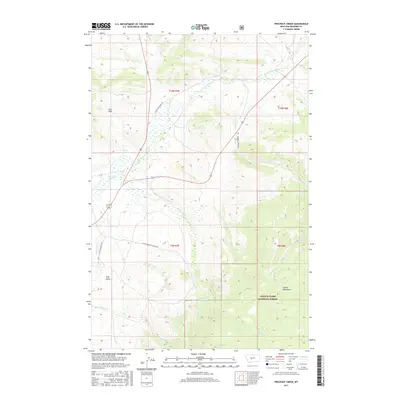
2017 Map of Pinchout Creek
USGS Topo · Published 2017About this map
Lewis & Clark National Forest encompasses the southeastern portion of this terrain, where the Castle Mountains rise above the surrounding valleys. The landscape is defined by a dense network of mountain drainage, with Pinchout Creek and Willow Creek feeding into the Willow Cr Reservoir. In the lower elevations, the N Fork Smith River serves as a primary waterway, joined by numerous tributaries like Trout Cr and Fourmile Cr. Human imprint is visible through established ranching and residential infrastructure, notably Castle Mtn Ranch Rd and the Castle Mountain Estate Rd corridor. Distinctive geological landmarks such as Clay Butte and the Park Hills provide clear orientation points for researchers studying the geography of Meagher County. The presence of the S Side Canal indicates managed water systems supporting the local agricultural and ranching economy.
Find a feature on this map
27 named features on this map. Tap any name to fly to it.
Don’t see what you’re looking for? This feature index may not catch every label — zoom into the map to look around manually.
Map Details
Editions of this 2017 Pinchout Creek Map
This is the sole edition of this map. No revisions or reprints were ever made.
Other maps of this area

1886 · Little Belt Mts.
USGS Topo · 1:250,000

1894 · Little Belt Mts.
USGS Topo · 1:250,000

1897 · Little Belt Mts.
USGS Topo · 1:250,000

1898 · Little Belt Mts.
USGS Topo · 1:250,000

1902 · Little Belt Mts.
USGS Topo · 1:250,000

1948 · White Sulphur Springs
USGS Topo · 1:250,000

1958 · White Sulphur Springs
USGS Topo · 1:250,000

1961 · White Sulphur Springs
USGS Topo · 1:250,000

1965 · White Sulphur Springs
USGS Topo · 1:250,000
1971 · White Sulphur Springs
USGS Topo · 1:24,000