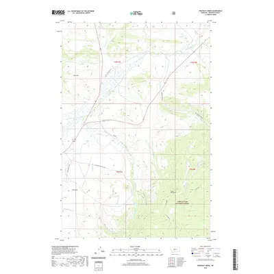
2020 Map of Pinchout Creek
USGS Topo · Published 2020About this map
The Castle Mountains rise sharply in this portion of Meagher County, where the high-altitude terrain is preserved within the Lewis & Clark National Forest. This landscape is defined by its complex drainage network, where the N Fork Smith River and tributaries like Pinchout Cr carve through the foothills. Water management is a central feature of the local geography, evidenced by the S Side Canal and the Willow Cr Reservoir, which capture runoff for use in the lower elevations.
Find a feature on this map
30 named features on this map. Tap any name to fly to it.
Don’t see what you’re looking for? This feature index may not catch every label — zoom into the map to look around manually.
Map Details
Editions of this 2020 Pinchout Creek Map
This is the sole edition of this map. No revisions or reprints were ever made.
Other maps of this area

1886 · Little Belt Mts.
USGS Topo · 1:250,000

1894 · Little Belt Mts.
USGS Topo · 1:250,000

1897 · Little Belt Mts.
USGS Topo · 1:250,000

1898 · Little Belt Mts.
USGS Topo · 1:250,000

1902 · Little Belt Mts.
USGS Topo · 1:250,000

1948 · White Sulphur Springs
USGS Topo · 1:250,000

1958 · White Sulphur Springs
USGS Topo · 1:250,000

1961 · White Sulphur Springs
USGS Topo · 1:250,000

1965 · White Sulphur Springs
USGS Topo · 1:250,000
1971 · White Sulphur Springs
USGS Topo · 1:24,000