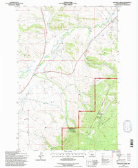
1995 Map of Pinchout Creek
USGS Topo · Published 1997About this map
The Lewis and Clark National Forest boundary marks a sharp transition between the open valley floor and the rising slopes of the Castle Mountains. This 1995 revision reveals a landscape defined by water management and mountain terrain, centered on the Smith River and its numerous tributaries. Significant hydraulic infrastructure is mapped in detail, including the South Side Canal and the South Side Canal Aqueduct, which divert water across the drainage of Pinchout Creek. Higher elevations are characterized by landmarks like Kings Hill and Clay Butte, alongside scattered mining activity noted by several Prospects and a Gravel Pit near the North Fork Smith River. The presence of the Willow Creek Reservoir and the Trinity Spring highlights the critical role of water sources in this part of Meagher County.
Find a feature on this map
29 named features on this map. Tap any name to fly to it.
Don’t see what you’re looking for? This feature index may not catch every label — zoom into the map to look around manually.
Map Details
Editions of this 1995 Pinchout Creek Map
This is the sole edition of this map. No revisions or reprints were ever made.
Other maps of this area

1886 · Little Belt Mts.
USGS Topo · 1:250,000

1894 · Little Belt Mts.
USGS Topo · 1:250,000

1897 · Little Belt Mts.
USGS Topo · 1:250,000

1898 · Little Belt Mts.
USGS Topo · 1:250,000

1902 · Little Belt Mts.
USGS Topo · 1:250,000

1948 · White Sulphur Springs
USGS Topo · 1:250,000

1958 · White Sulphur Springs
USGS Topo · 1:250,000

1961 · White Sulphur Springs
USGS Topo · 1:250,000

1965 · White Sulphur Springs
USGS Topo · 1:250,000
1971 · White Sulphur Springs
USGS Topo · 1:24,000