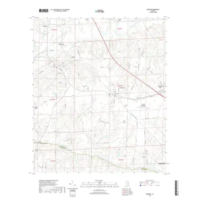
2018 Map of Pinckard
USGS Topo · Published 2018About this map
The Choctawhatchee River and its numerous tributaries, including Mossy Camp Br and Soapstone Br, define the landscape of this region on the border of Dale and Houston counties. The area is anchored by the established settlements of Newton and Pinckard, connected by a network of local roads such as Waterford Rd and Co Rd 14. Genealogy researchers will find several significant burial sites, including Newton City Cem and Pinckard Cem, while the northern reaches show the confluence of the river's east and west forks near Woodham Bridge. The presence of Blessings Landing Air Ranch Airport and Liberty Field reflects the modern intersection of rural land use and private aviation. Near Midland City, the terrain transitions toward the growing outskirts of Dothan in the southeast corner of the map.
Find a feature on this map
100 named features on this map. Tap any name to fly to it.
Don’t see what you’re looking for? This feature index may not catch every label — zoom into the map to look around manually.
Map Details
Editions of this 2018 Pinckard Map
This is the sole edition of this map. No revisions or reprints were ever made.
Other maps of this area

1942 · Enterprise
USGS Topo · 1:125,000

1948 · Ozark
USGS Topo · 1:62,500

1950 · Ozark
USGS Topo · 1:62,500

1953 · Dothan
USGS Topo · 1:250,000

1954 · Dothan
USGS Topo · 1:250,000

1955 · Dothan
USGS Topo · 1:250,000

1957 · Malvern
USGS Topo · 1:24,000

1957 · Hartford
USGS Topo · 1:62,500
1957 · Clayhatchee
USGS Topo · 1:24,000

1960 · Ewell
USGS Topo · 1:24,000