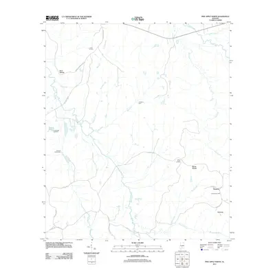
2011 Map of Pine Apple North
USGS Topo · Published 2011About this map
Monterey and the community of Harmony anchor the southeastern corner of this rural Wilcox County landscape, where family heritage is deeply etched into the geography. A network of country roads, including the descriptively named Ward and Grimes Mill Rd and Snow Hill Short Cut Rd, connects isolated settlements and historical landmarks like Mount Moriah church. The terrain is defined by its watercourses, with the winding paths of Pine Barren Creek, Wolf Creek, and Beaver Creek carving through the countryside.
Find a feature on this map
31 named features on this map. Tap any name to fly to it.
Don’t see what you’re looking for? This feature index may not catch every label — zoom into the map to look around manually.
Map Details
Editions of this 2011 Pine Apple North Map
This is the sole edition of this map. No revisions or reprints were ever made.
Other maps of this area

1953 · Montgomery
USGS Topo · 1:250,000

1953 · Andalusia
USGS Topo · 1:250,000

1956 · Montgomery
USGS Topo · 1:250,000

1957 · Montgomery
USGS Topo · 1:250,000

1957 · Andalusia
USGS Topo · 1:250,000

1957 · Carlowville
USGS Topo · 1:62,500

1957 · Braggs
USGS Topo · 1:62,500
1981 · Oak Hill
USGS Topo · 1:24,000

1981 · Pine Apple North
USGS Topo · 1:24,000

1981 · Forest Home
USGS Topo · 1:24,000