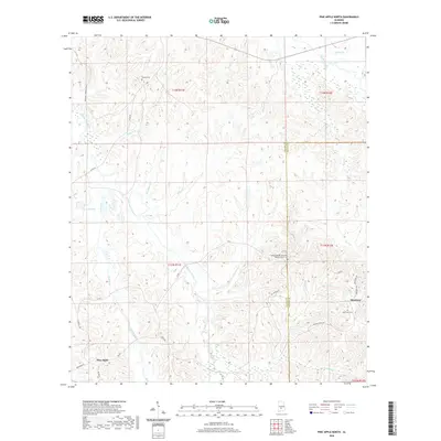
2020 Map of Pine Apple North
USGS Topo · Published 2020About this map
Pine Apple and Monterey anchor this rural landscape in Wilcox and Butler counties, where a complex network of waterways defines the terrain. The northern reaches are shaped by Cedar Creek and Wildcat Cr, while Pine Barren Creek and Turkey Creek flow through the central and western sections. This 2020 data captures a region where community life is often centered around local landmarks such as the Mount Moriah Fellowship Baptist Church Cem and several other burial grounds, including Palmer Cem and Monterey Cem. The map illustrates the persistent intersection of natural features and established rural roads like Co Rd 7 and Monterey Rd, showing how modern access routes still follow the contours of the Alabama creek valleys. This specific sheet provides a clear view of the transitions between lowlands near Donald Lake and the higher ground marking the county boundary.
Find a feature on this map
33 named features on this map. Tap any name to fly to it.
Don’t see what you’re looking for? This feature index may not catch every label — zoom into the map to look around manually.
Map Details
Editions of this 2020 Pine Apple North Map
This is the sole edition of this map. No revisions or reprints were ever made.
Other maps of this area

1953 · Montgomery
USGS Topo · 1:250,000

1953 · Andalusia
USGS Topo · 1:250,000

1956 · Montgomery
USGS Topo · 1:250,000

1957 · Montgomery
USGS Topo · 1:250,000

1957 · Andalusia
USGS Topo · 1:250,000

1957 · Carlowville
USGS Topo · 1:62,500

1957 · Braggs
USGS Topo · 1:62,500
1981 · Oak Hill
USGS Topo · 1:24,000

1981 · Pine Apple North
USGS Topo · 1:24,000

1981 · Forest Home
USGS Topo · 1:24,000