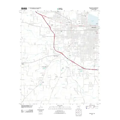
2011 Map of Pine Bluff
USGS Topo · Published 2011About this map
The University of Arkansas at Pine Bluff and the historic city center of Pine Bluff anchor the northern portion of this landscape, where the urban grid meets the meandering path of Bayou Bartholomew. The area is characterized by an extensive collection of burial sites serving various communities, including Graceland Cemetery, Miller Cemetery, Bellwood Cemetery, and Saint Josephs Cemetery. Moving south from the city, the map transitions into a network of small settlements and water management features like Watson Chapel and Sorrells. The presence of numerous engineered water bodies, such as Suburbia Lake and Midland Lake, alongside their respective dams, illustrates a managed hydrological environment designed to control the flow toward Boggy Bayou. These landmarks, along with the Southeast Arkansas Livestock Showgrounds, reflect the regional intersection of education, agriculture, and civic development in Jefferson County during the early 21st century.
Find a feature on this map
165 named features on this map. Tap any name to fly to it.
Don’t see what you’re looking for? This feature index may not catch every label — zoom into the map to look around manually.
Map Details
Editions of this 2011 Pine Bluff Map
This is the sole edition of this map. No revisions or reprints were ever made.
Other maps of this area

1932 · Pastoria
USGS Topo · 1:62,500

1935 · Altheimer
USGS Topo · 1:62,500

1935 · Pastoria
USGS Topo · 1:62,500

1935 · Noble Lake
USGS Topo · 1:62,500

1948 · Helena
USGS Topo · 1:250,000

1950 · Helena
USGS Topo · 1:250,000

1955 · Helena
USGS Topo · 1:250,000

1955 · Little Rock
USGS Topo · 1:250,000

1956 · Little Rock
USGS Topo · 1:250,000

1959 · Helena
USGS Topo · 1:250,000