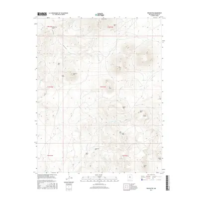
2017 Map of Pine Buttes
USGS Topo · Published 2017About this map
Laughlin Peak dominates the northern horizon of this high-altitude landscape, where volcanic features and mesas define the eastern New Mexico terrain. The drainage patterns of Tinaja Cr and the Rio del Plano carve through a region marked by named peaks like Raspberry Mtn and Pine Buttes. Evidence of early settlement is concentrated at the Wilson Cem, a small burial site located west of the volcanic formation known as The Crater.
Find a feature on this map
35 named features on this map. Tap any name to fly to it.
Don’t see what you’re looking for? This feature index may not catch every label — zoom into the map to look around manually.
Map Details
Editions of this 2017 Pine Buttes Map
This is the sole edition of this map. No revisions or reprints were ever made.
Other maps of this area

1954 · Raton
USGS Topo · 1:250,000

1958 · Raton
USGS Topo · 1:250,000

1965 · Sauble Circle Dot Ranch
USGS Topo · 1:24,000

1971 · Kiowa
USGS Topo · 1:24,000

1971 · Tres Hermanos Peak
USGS Topo · 1:24,000

1971 · Pine Buttes
USGS Topo · 1:24,000
1971 · Tinaja Mountain
USGS Topo · 1:24,000

1971 · Palo Blanco Mountain
USGS Topo · 1:24,000
1971 · Mesa Larga
USGS Topo · 1:24,000

1974 · Point Of Rocks Mesa
USGS Topo · 1:24,000