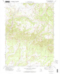
1972 Map of Pine Canyon
USGS Topo · Published 1976About this map
Clark Valley and the high plateaus of the West Tavaputs region define this 1970s topographic study. The landscape is carved by a radial drainage pattern where Nine Mile Creek and Soldier Creek descend from the upland meadows of Whitmore Park. While the terrain is primarily shaped by its hydrology, human industrial activity is evident through a network of Jeep Trails and a significant Pipeline crossing the northern heights. Resource exploration is documented by several Drill Holes, a labeled Mine, and scattered Prospects near Dugout Creek. The map provides a clear record of the area's mid-century transition as energy infrastructure began to mark the canyon floors and ridges, particularly around the headwaters of Fish Creek and Pace Creek.
Find a feature on this map
19 named features on this map. Tap any name to fly to it.
Don’t see what you’re looking for? This feature index may not catch every label — zoom into the map to look around manually.
Map Details
Editions of this 1972 Pine Canyon Map
2 editions found
Other maps of this area

1886 · Price River
USGS Topo · 1:250,000

1896 · Price River
USGS Topo · 1:250,000

1915 · Sunnyside
USGS Topo · 1:62,500

1915 · Wellington
USGS Topo · 1:62,500

1956 · Price
USGS Topo · 1:250,000

1960 · Price
USGS Topo · 1:250,000

1962 · Price
USGS Topo · 1:250,000

1968 · Wood Canyon
USGS Topo · 1:24,000
1969 · Minnie Maud Creek East
USGS Topo · 1:24,000
1969 · Minnie Maud Creek West
USGS Topo · 1:24,000