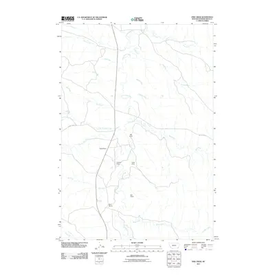
2011 Map of Pine Creek
USGS Topo · Published 2011About this map
The Little Powder River creates a central corridor through this section of Powder River County, Montana, carving a path through a landscape defined by dramatic breaks and named drainage basins. Local landmarks such as Bell Tower and Rocky Butte provide prominent vertical orientation in a territory otherwise dominated by the winding tributaries of Pine Creek, Belle Creek, and Allison Creek. The map reflects a rural infrastructure based on expansive cattle ranching or land management, where movement is dictated by the terrain of Big Gulch and the seasonal flows of Preacher Draw and Pease Draw. Remote access is maintained by dirt thoroughfares like Baking Powder Rd and Belle Creek Rd, which follow the contours of the high plains. This record of the early twenty-first century documents the enduring geographic features that have dictated movement and land use in the Big Sky country for generations.
Find a feature on this map
22 named features on this map. Tap any name to fly to it.
Don’t see what you’re looking for? This feature index may not catch every label — zoom into the map to look around manually.
Map Details
Editions of this 2011 Pine Creek Map
This is the sole edition of this map. No revisions or reprints were ever made.
Other maps of this area

1954 · Ekalaka
USGS Topo · 1:250,000

1956 · Ekalaka
USGS Topo · 1:250,000

1958 · Ekalaka
USGS Topo · 1:250,000

1965 · Ekalaka
USGS Topo · 1:250,000

1970 · Pine Creek
USGS Topo · 1:24,000

1970 · Sanburn Reservoir
USGS Topo · 1:24,000

1970 · Wild Bill Creek
USGS Topo · 1:24,000

1970 · Belle Creek SW
USGS Topo · 1:24,000
1970 · Biddle
USGS Topo · 1:24,000

1970 · Bear Skull Mountain
USGS Topo · 1:24,000