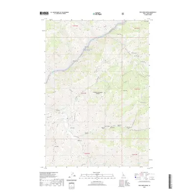
2020 Map of Pine Creek Rapids
USGS Topo · Published 2020About this map
Salmon Wild and Scenic River carves through the northern reaches of this Lemhi County landscape, where the Salmon River meets Dutch Oven Rapids near Eagles Nest. This terrain within the Salmon National Forest is defined by a dense network of drainages and named gulches that suggest a history of resource extraction and early mountain transit. Panther Creek and Beaver Creek converge in the south, while names like Sawmill Gulch, German Gulch, and Copper Canyon point to the area's industrial past.
Find a feature on this map
53 named features on this map. Tap any name to fly to it.
Don’t see what you’re looking for? This feature index may not catch every label — zoom into the map to look around manually.
Map Details
Editions of this 2020 Pine Creek Rapids Map
This is the sole edition of this map. No revisions or reprints were ever made.
Other maps of this area

1950 · Blackbird Mtn
USGS Topo · 1:62,500

1950 · Leesburg
USGS Topo · 1:62,500

1951 · Leesburg
USGS Topo · 1:62,500

1951 · Blackbird Mtn
USGS Topo · 1:62,500

1956 · Elk City
USGS Topo · 1:250,000

1960 · Elk City
USGS Topo · 1:250,000

1960 · Ulysses Mtn
USGS Topo · 1:62,500

1960 · Shoup
USGS Topo · 1:62,500

1982 · Bighorn Crags
USGS Topo · 1:100,000
1989 · Jureano Mountain
USGS Topo · 1:24,000