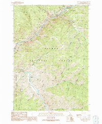
1991 Map of Pine Creek Rapids
USGS Topo · Published 1991About this map
The Salmon River carves a deep path through the Salmon River Mountains in this 1991 survey, which captures a landscape defined by its mining history and wilderness conservation. The northeast corner is particularly concentrated with mineral claims, including the Gold Hill Mine, Kentucky Mine, and Clipper Bullion Mine situated along the river's bends. These sites, along with the Big Lead Mine further east, suggest a period of intensive prospecting in the Idaho backcountry before much of the territory was preserved within the Salmon National Forest.
Find a feature on this map
40 named features on this map. Tap any name to fly to it.
Don’t see what you’re looking for? This feature index may not catch every label — zoom into the map to look around manually.
Map Details
Editions of this 1991 Pine Creek Rapids Map
This is the sole edition of this map. No revisions or reprints were ever made.
Other maps of this area

1950 · Blackbird Mtn
USGS Topo · 1:62,500

1950 · Leesburg
USGS Topo · 1:62,500

1951 · Leesburg
USGS Topo · 1:62,500

1951 · Blackbird Mtn
USGS Topo · 1:62,500

1956 · Elk City
USGS Topo · 1:250,000

1960 · Elk City
USGS Topo · 1:250,000

1960 · Ulysses Mtn
USGS Topo · 1:62,500

1960 · Shoup
USGS Topo · 1:62,500

1982 · Bighorn Crags
USGS Topo · 1:100,000
1989 · Jureano Mountain
USGS Topo · 1:24,000