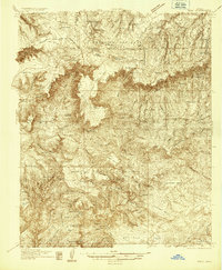
1934 Map of Pine
USGS Topo · Published 1934About this map
The dramatic precipice of the Mogollon Rim bisects this mid-1930s survey, marking a sharp geological divide between the high plateaus of the Coconino National Forest and the complex canyon systems of the Tonto National Forest below. Early 20th-century settlement is concentrated in the small communities of Pine and Strawberry, where ranching and early tourism began to take root. The map records a landscape still defined by its cattle-country origins and early mining efforts, featuring family-named landmarks like Chase Ranch and working structures such as Whiterock Corral. Mineral exploration is evident in the south, where the Crackerjack Mine, White Oak Mine, and Rowen Mine are located amidst a network of mesas including Buckhead Mesa and Houston Mesa. One of the most distinctive natural landmarks noted is the Natural Bridge, located south of Pine, which remains a focal point for the region's unique geography.
Find a feature on this map
70 named features on this map. Tap any name to fly to it.
Don’t see what you’re looking for? This feature index may not catch every label — zoom into the map to look around manually.
Map Details
Editions of this 1934 Pine Map
2 editions found
Other maps of this area

1887 · Verde
USGS Topo · 1:250,000

1892 · Verde
USGS Topo · 1:250,000

1923 · Camp Verde
USGS Topo · 1:125,000

1929 · Turret Peak
USGS Topo · 1:125,000

1932 · Camp Verde
USGS Topo · 1:125,000

1933 · Turret Peak
USGS Topo · 1:125,000

1934 · Pine
USGS Topo · 1:62,500

1934 · Promontory Butte
USGS Topo · 1:62,500

1936 · Camp Verde
USGS Topo · 1:125,000

1936 · Payson
USGS Topo · 1:48,000